")
Etowah Mounds (also known as Etowah Indian Mounds) is a National Historic Landmark and archaeological site near Cartersville, Georgia, USA, enclosing the ruins of a prehistoric Native American city whose original name is unknown. The present designation of Etowah means "town" in the language of the Muscogee-Creek Native Americans.
The city was built in three phases between c. 1000 - c. 1550 and the present site encloses three large and three smaller mounds surrounding a central plaza. The three large mounds were the chief’s residence (Mound A), the ceremonial site for religious rituals (Mound B), and the burial site for the nobility (Mound C); the smaller mounds are each attached or nearby the larger. Between the three was a plaza, which served for ceremonies, commerce, and as a ball field.
The city was built and flourished during the period known as the Mississippian culture (c. 1100-1540 CE) when many of the best-known mound sites in North America – such as Cahokia and Moundville – were also constructed. The city seems to have developed from a small village community of the Woodland Period (c. 500 BCE - 1100 CE) whose inhabitants were related to those who built Etowah and the later Creek and Muskogee Native American tribes of the region who lived in and near the site.
The Cherokee Nation arrived in the region from the north in the 15th century CE and settled at Etowah, but they, like many others in the area, had their numbers depleted by European diseases they had no immunity to. The Creek and Cherokee remained on the land, however, until gold was discovered in the region and they were forcibly removed to Oklahoma by order of President Andrew Jackson (served 1829-1837) in the 1830s, a tragic loss of land and heritage to the First Nations through the forced migration that has come to be known as the Trail of Tears.
The mounds were first noted by Americans in 1817 and test-sited in 1883 but no major excavations were begun until 1925 when the famous (or infamous) archaeologist Warren K. Moorehead (l. 1866-1939) arrived at the site. Moorehead’s work on Mound C – the most completely excavated area of the site to date – unearthed a number of significant artifacts which enabled the dating of the site to the Mississippian culture period. Excavations since Moorehead’s have been sporadic, but it is believed, based on what has been found and the general preservation of the site, that Etowah is the most intact of the Mississippian culture mound sites of the southeast built by the ancestors of the Muscogee-Creek Nation.
The Mound Builders & Mississippian Culture
The Mississippian culture is often cited as though it were the beginning of monumental mound-building, but mounds were built thousands of years before in North America. Watson Brake Mounds dates to c. 3500 BCE and Poverty Point to c. 1700-1100 BCE, with the Mississippian culture’s mounds following. The Mississippian culture has become the best known and most closely associated with mound-building, however, owing to the proliferation of mounds prior to that period and the skill of the people of the Adena culture (c. 800 BCE - 1 CE) and the Hopewell culture (c. 100 BCE-500 CE) who perfected mound-building and provided the model for later works such as the famous Mississippian Cahokia Mounds and Moundville.
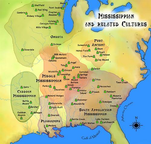
Many mounds were constructed during the Archaic Period (c. 8000-1000 BCE) and the Woodland Period (c. 500 BCE - 1100 CE), but these differed from the later Mississippian culture sites, such as Etowah, in that those of the Adena were conical while those of the Hopewell were either effigy or flat-topped mounds. The Mississippian culture borrowed from both traditions in the creation of their mounds which were influenced, at least in part, by the religious beliefs spread throughout the region by the Hopewell culture.
Native American Religion
Native American religion took the form of animism – the belief that everything is animated by a spirit which lives on after the physical body has died and all things are connected in an intricate web of reciprocity – and it is thought the construction of the mounds, at Etowah and elsewhere, was an expression of this belief. The people devoted themselves to the systematic removal of soil from one place to another for the greater good of the community in honoring the spirits of a given place and raising their chief and/or priests to a higher level, closer to the sun, which was considered a god. This could be considered an act of reciprocity in that the people were providing a “home” for the spirits, focusing the energy of those spirits for the good of the community, and then giving back to the spirits through ritualistic ceremonies.
To commune with the spirits and gods, the people needed to alter how they experienced the world around them, and this was accomplished through rituals, which might have included the act of mound-building, but certainly involved the mounds themselves which elevated participants. Hallucinogens in the form of especially strong tobacco, cultivated by the Adena and Hopewell early on and then by the Mississippian culture, are also thought to have played a part in this communion. Scholar Charles C. Mann comments:
The Hopewell apparently sought spiritual ecstasy by putting themselves into trances, perhaps aided by tobacco. In this enraptured state, the soul journeys to other worlds. As is usually the case, people with special abilities emerged to assist travelers through the portal to the numinous. Over time, these shamans became gatekeepers, controlling access to the supernatural realm. They passed on their control and privileges to their children, creating a hereditary priesthood: counselors to kings, if not kings themselves. They acquired healing lore, mastered and invented ceremonies, learned the numerous divinities in the Hopewell pantheon. We know little of these gods today because few of their images have endured to the present. Presumably, shamans recounted their stories to attentive crowds; almost certainly, they explained when and where the gods wanted to build mounds. In the context of the village, the mound, visible everywhere, was as much a beacon as a medieval cathedral. As with Gothic churches, which had plazas for the outdoor performance of sacred mystery plays, the mounds had greens before them: ritual spaces for public use. (294-295)
The mound sites of the Mississippian culture – as well as those constructed earlier such as Poverty Point – follow this model. It is also likely that the people of the Mississippian culture also used tobacco to alter consciousness as that was one of the crops they raised, along with corn, beans, and squash. These crops were used in paying laborers for building mounds and other tasks as well as in trade with other communities, often across vast distances. Mound B at Etowah seems to have been used for rituals but artifacts from the plaza below Mound A suggest the same for that area. It is possible Mound A, which supported the chief’s residence, was also considered the home of the spirits of the place and the plaza served as the primary place for honoring them in rituals.
Etowah Mounds
How the mounds were used is actually still not entirely clear as so little of the site has been excavated, but what is clear is that Etowah Mounds are among the best representations of the work of the Mississippian culture, featuring three flat-topped mounds surrounding the central plaza. As noted, the site was completed in three phases during the different periods of the Mississippian culture:
- Early Mississippian: c. 1000-1200 CE
- Middle Mississippian: c. 1200-1375 CE
- Late Mississippian: c. 1375-1540 CE
The city is thought to have developed from an earlier village on the site associated with the Swift Creek Culture who were mound builders of the Middle Woodland Period and created the Leake Mounds two miles west of Etowah. The Swift Creek peoples, like many early mound builders, were hunter-gatherers who devoted a significant amount of time to constructing their mounds and then abandoned them and moved on. This certainly seems to be the case with the Leake Mounds as the site was abandoned c. 650 CE and at Etowah as well since artifacts found on site suggest the earlier Swift Creek village was abandoned c. 600 CE.
Whether the Swift Creek began any of the mounds presently at Etowah is unknown, as only Mound C has been excavated to any significant degree, but this is a possibility. The location and height of the mounds seem to honor the chief, religious ceremonies, and the departed in descending order of largest-to-smallest mounds, although this claim is speculative and the size may have nothing to do with the significance.
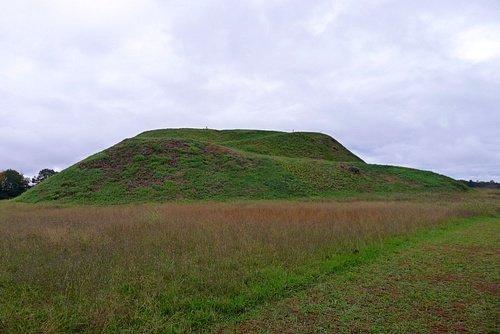
- Mound A – site of the chief’s residence – is 63 feet (19 m) tall and was once topped by four buildings surrounding a courtyard.
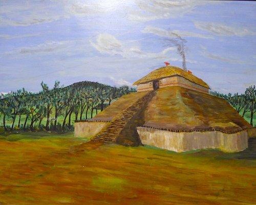
- Mound B – site of religious rituals – is 25 feet (7.6 m) tall and seems to have had temples on it.
- Mound C – a burial mound – rises 10 feet (3 m) tall and also had a temple or chapel at the top.
Mound A is situated directly before the central plaza of the city with the other two mounds off to the side. The chief of the community was early on known by the title "Brother of the Sun" and was thought to be able to commune directly with the sun god. His mound at Etowah is the highest to elevate him closer to his “brother” in the sky and enable more direct communication. The ceremonies enacted on Mound B may have been funerary rituals associated with Mound C, but this is unclear.
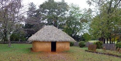
The lower-class lived in wood and thatch homes surrounding the plaza and the mounds, and there seem to have been industrial and commercial structures in that area as well. To date, 140 structures have been identified at the site through postholes, debris, and by using magnetometers which can detect anomalies under the ground which, when analyzed, suggest ancient trenches, buildings, and walls. By using magnetometers, archaeologists can avoid disturbing the surfaces of the mounds and plaza. Magnetometers have also identified a palisade, a wooden stockade fence, and a moat which encircled the site on three sides, the fourth side open to the Etowah River. The palisade featured watchtowers spaced at intervals of 80 feet (24 m) from the opening on the river in a semicircle ending back at the river on the far side.
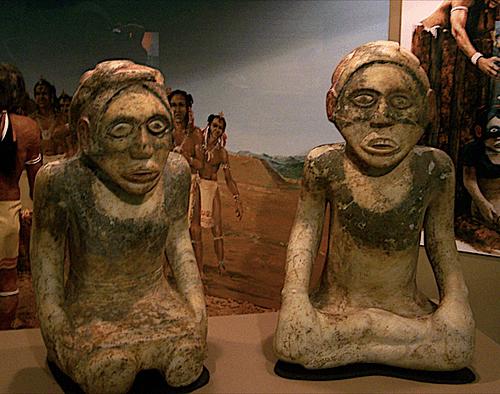
The people engaged in long-distance trade, which brought raw materials not sourced locally, such as marble, which was used to create the famous Etowah Statues, paired figures of a man and woman thought to have been used as effigies in religious rituals honoring the peoples’ ancestors. Daily life centered around hunting, fishing, and tending crops as well as working on the mounds, religious ceremonies, and leisure activities.
Among the most popular of the latter were ball games, one of which resembled modern-day lacrosse and the other a game called 'chunkey' in which players would throw carved sticks toward a rolling disk, trying to have their sticks land as close to the disk’s final resting place as possible; the player whose stick was closet scored the point and the first to reach 12 points was the winner. Chunkey was taken quite seriously, and large bets seem to have been made on the game, based on later reports by European explorers, with losers sometimes opting for suicide rather than live with the loss and attendant shame involved.
The site was still inhabited in 1540 when the Spanish conquistador Hernando de Soto (l. c. 1500-1542) arrived in the area in search of gold. De Soto’s reports include mention of a village they called Itaba (translated as “boundary”) which later scholars have associated with Etowah. De Soto’s small army of 550 men, African and Mexican slaves, and war dogs ravaged the area as they were convinced the natives were hiding huge quantities of gold. Scholar James Wilson notes:
The Indians signaled De Soto’s approach with a relay of beacon-fires, but they were unable to stop the expedition which left a trail of desecrated temples, plundered storehouses, and razed towns in its wake. (135)
De Soto died of “Old World Fever” while still searching the region for gold, and the pathogens of whatever this European disease was spread among the natives who had no natural immunity to them. Between European-borne disease and the wholesale slaughter of villages who "refused to give up their gold", the population of the region was greatly reduced overall, and this same most likely happened at Etowah. De Soto’s chroniclers report him ordering the destruction of villages and towns where "the cries of the women and children were such as to deafen those who pursued them" (Wilson, 137), and it is possible this same policy was engaged in at Etowah.
American Discovery & Removal of Tribes
Whatever happened to the original inhabitants, the Muscogee-Creek tribe, who claimed ancestral ties to Etowah, were living at the site in the late 15th century CE when the Cherokee are thought to have arrived from the Great Lakes region to the north. By 1800, the Cherokee had long been settled and were the tribe to introduce Americans to Etowah. The first American report concerning Etowah comes from the minister Elias Cornelius (l. 1758-1823), an evangelist to the natives who traveled the region converting them to Christianity and establishing schools to 'civilize' them. Cornelius engaged with the Cherokee near Etowah who brought him to the site in 1817. He recorded the event and an admiring description of the mounds in his journal, but this was not published until 1833.
By that time, the Georgia Gold Rush (c. 1829-1840) was well underway, and speculators rushed to the region in hopes of becoming wealthy. Cornelius’ account of Etowah, even if any of them had read it, would not have changed anything as the Americans had long followed a policy of disrespecting Native American traditions and land rights and certainly would not have paused at this point to consider the ancient claim the natives had to the land, especially when gold was involved. By 1830, there were thousands of miners along the Etowah River and the Muscogee-Creek, the Cherokee, and other nations, deprived of necessary resources, fought back against the influx of immigrants.
President Andrew Jackson responded to the mounting tensions by signing the Indian Removal Act of 1830. Although the Creek, Cherokee, and others appealed to the Supreme Court to keep the lands, they lost their case and were removed to Oklahoma and other points west. This forced migration of over 60,000 Native Americans is known as the Trail of Tears because of the number of natives who died on the march as well as the loss of their lands to greedy speculators, who once they had exhausted the gold veins, abandoned the area for the next one promising riches.
Conclusion
In 1883, ethnologist Cyrus Thomas (l. 1825-1910) and archaeologist John P. Rogan (c. 1880s) made the first test excavations at Etowah for the Smithsonian Institute. Rogan, working under Thomas’ direction, discovered the copper plates now known as the Etowah Plates as well a number of other artifacts now on exhibit at the Smithsonian.
The first full-scale excavation of the Etowah site was not initiated until 1925 under the direction of Warren K. Moorehead, who is both praised and criticized for his work at Etowah and elsewhere. Moorehead was consistently object-oriented, and he frequently engaged in destructive measures in his quest for museum-worthy artifacts. He worked four seasons at Etowah, concentrating on Mound C which rewarded his efforts with a number of significant finds. When mounds A and B failed to do the same, he abandoned his efforts.
As of 2021, only 9 percent of the site has been excavated and cataloged in spite of periodic digs from Moorehead’s time to the present. Today, Etowah is protected as a National Historic Landmark and is open to the public as an archaeological park. The on-site museum contains artifacts excavated from the mounds and the surrounding area and also offers interactive displays on the history of the Native Americans who built the great mounds and lived in the area for thousands of years before the arrival of the European immigrants whose descendants now occupy the land surrounding the site.